northsouth SouthKorea
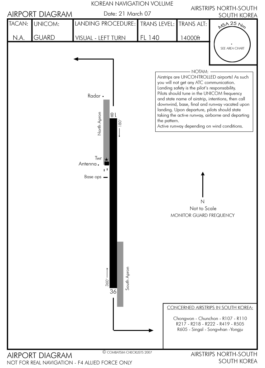
KOREAN NAVIGATION VOLUME Datę: 21 March 07
AIRSTRIPS NORTH-SOUTH SOUTH KOREA
|
TACAN: |
UNICOM: |
LANDING PROCEDURĘ: |
TRANS LEVEL: |
TRANS ALT: |
|
N.A. |
GUARD |
VISUAL - LEFT TURN |
FL 140 |
14000ft |
81
-NOTAM: -
Airsłrips are UNCONTROLLED airports! As such you will not get any ATC communication.
Landing safety is the pilot's responsabiliły.
Pilots should tune in łhe UNICOM frequency and stałe name oł airstrip, intentions, then cali downwind, base, finał and runway vacated upon landing. Upon departure, pilots should stałe taking the active runway, airborne and departing the pattern.
Active runway depending on wind conditions.
c
z
Base ops .
36
CONCERNED AIRSTRIPS IN SOUTH KOREA:
Chongwon - Chunchon - R107 - R110 R217 - R218 - R222 - R419 - R505 R605 - Singal - Songwhan -Yongju
© COMBATSIM CHECKLISTS 2007
AIRSTRIPS NORTH-SOUTH SOUTH KOREA
Wyszukiwarka
Podobne podstrony:
northsouth NorthKorea AIRPORT DIAGRAM KOREAN NAVIGATION VOLUME Datę: 21 March 07 AIRSTRIPS NORTH-SOU
eastwest NorthKorea AIRPORT DIAGRAM KOREAN NAVIGATION VOLUME Datę: 21 March 07 AIRSTRIPS EAST-WEST N
mandumi airport diagram AIRPORT DIAGRAM KOREAN NAVIGATION VOLUME Datę: 21 March 2007 MANDUMI AB SOUT
Suwon airport AIRPORT DIAGRAM KOREAN NAVIGATION VOLUME Datę: 20 March 07 SUWON AIRBASE (RKSW) SOUTH
fukuoka toyotadep DE PARTU RE KOREAN NAVIGATION VOLUME Datę: 21 March 07 FUKUOKA (KADENA)(RJFF)
eastwest SouthKorea AIRPORT DIAGRAMKOREAN NAVIGATION VOLUME Datę: 21 March 07AIRSTRIPS EAST-WEST SOU
airport diag Chongju AIRPORT DIAGRAM KOREAN NAVIGATION VOLUME Datę: 1 3 March 2007 CHONGJU INTL (RKT
airport diag AIRPORT DIAGRAM KOREAN NAVIGATION VOLUME Datę: 1 2 March 07 OSAN AB (RKSO) SOUTH KOREA
Kunsan tacan4R TACAN RWY 34R KOREAN NAVIGATION VOLUME Datę: 13 march 07 KUNSAN AB (RKJK) SOUTH
więcej podobnych podstron